This dawned on me when talking with my nephews over the holidays. At the time, I simply dismissed as trivial banter without real purpose. Frankly I don’t even remember how it got started, but it had something to do with defining an island, and the difference between an island and a continent. I remember immediately going to the web, and found the following definitions:
From Dictionnary.com:
is·land
-
A tract of land completely surrounded by water, and not large enough to be called a continent.
-
Something resembling an island, especially in being isolated or having little or no direct communicationwith others.
-
A raised platform with a counter or other work surface on top situated in the middle area of a room,especially a kitchen, so as to permit access from all sides.
-
Safety island.
-
A low concrete platform for gasoline pumps at an automotive service station.
Ignoring definitions 3, 4 and 5 it seems that the definition of island is mostly a circular definition, and contextualized in not being a continent. Interestingly enough, looking at the definition of continent, we don’t get much more.
con·ti·nent
-
one of the main landmasses of the globe, usually reckoned as seven in number (Europe, Asia, Africa, North America, South America, Australia, and Antarctica).
-
a comparable landmass on another planet.
-
the mainland, as distinguished from islands or peninsulas.
-
the mainland of Europe, as distinguished from the British Isles.
-
a continuous tract or extent, as of land.
In short, it’s either something so obvious due to its scale.
Wikipedia was not much better, but actually starts to move towards an operating definition.
“Greenland is the world’s largest island with an area of over 2.1 million km², while Australia, the world’s smallest continent has an area of 7.6 million km², but there is no standard of size which distinguishes islands from continents, or from islets. There is a difference between islands and continents in terms of geology. Continents sit on continental lithosphere which is part of tectonic plates floating high on Earth’s molten mantle. Oceanic crust is also part of tectonic plates, but it is denser than continental lithosphere, so it floats low on the mantle. Islands are either extensions of the oceanic crust (e.g. volcanic islands) or geologically they are part of some continent sitting on continental lithosphere (e.g. Greenland). This holds true for Australia, which sits on its own continental lithosphere and tectonic plate.”
SOURCE: http://en.wikipedia.org/wiki/Island
So in a way, we now have three rules to determine whether New England is an island.
- Must be surrounded by water (hard rule)
- Must be in the surface area range outlined above (soft rule)
- Must be an “extension of the oceanic crust, or part of some continent” (hard rule).
So… is New England an Island? Let’s test it!
Rule 1: Surrounded by water: TRUE
The eastern section of New England is clearly water. It’s the Atlantic Ocean. But let’s anchor our area of exploration on two landmarks. The Southernmost point being the mouth of the Hudson river in Manhattan (NYC), and the Northernmost point being the mouth of the Saint Lawrence River, in Quebec City. So the question now is can you connect New York City and Manhattan through river ways alone. Let’s start from the North. The St. Lawrence river flows unobstructed (spare a dam or bridge here or there) from Lake Ontario all the way to Quebec City. However, a little North of Montreal is the little town of Sorel, which has (as far as I know) no distinguishing feature other than being where the Richelieu river joins with the St. Lawrence river.
If you follow the Richelieu river south bound, it will take you through the beautiful pastoral countryside of Quebec, and ultimately take you to the Lake Champlain (note, we’re going up stream here). Lake Champlain is where Canada, and the US come together, but also where New York and Vermont come together. If you go to the southern most part of lake Champlain, there is the small Poultney river that reaches Whitehall, NY. This is where the one of the NY Canals takes you from Whiehall all the way down to Fort Edward (near Glenn Falls and Hudson Falls), and runs into the Hudson river. The Hudson river, as we know, runs all the way down to New York City. So there you have it, we’ve been able to a land mass by connecting a number of streams.
Rule 2: Surface Area between 2.1 and 7.6 million km² (and ideally closer to 2.1): TRUE
Using Google Maps, we can measure the surface area (I used http://www.freemaptools.com/area-calculator.htm) and got the total area of 425 thousand km2. So well within the 2.1 million km2.
Rule 3: Part of some continent: TRUE
New England stands on the North American Plate.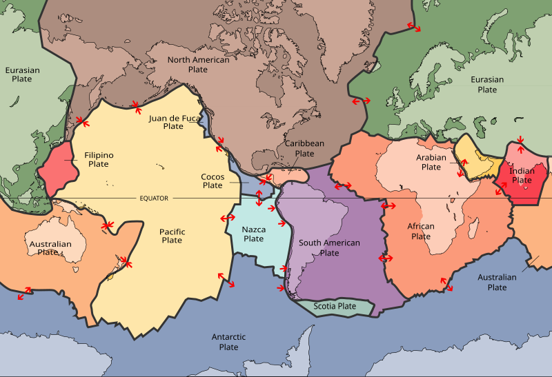
So yes, New England is an island. Of course, this relies on the man made canals in upstate New York.
But I think the point here is deeper. It’s really about context. We so often get stuck in what we believe to be true (namely that New England is not an Island). But in fact if we look more closely we can easily be surprised by what we see.
Leave a Reply
You must be logged in to post a comment.